
FloodFinder™: Stay Informed.
Be Climate Resilient.
Transforming Flood Management & Empowering Communities
FloodFinder™ is an innovative technology platform designed to strengthen situational awareness and resilience in local governments and communities.
Leverage the true power of observation for decision making and emergency response.
NGE uses advanced satellite imaging technology. FloodFinder™ provides real-time data on flooding events, either from overland flow or ice jams, helping municipalities and citizens stay informed, prepared, and proactive in flood management.
This state-of-the-art platform plays an important role in supporting effective flood management strategies, improving emergency communication, and fostering community resilience by offering critical insights into flood risks and real-time conditions.
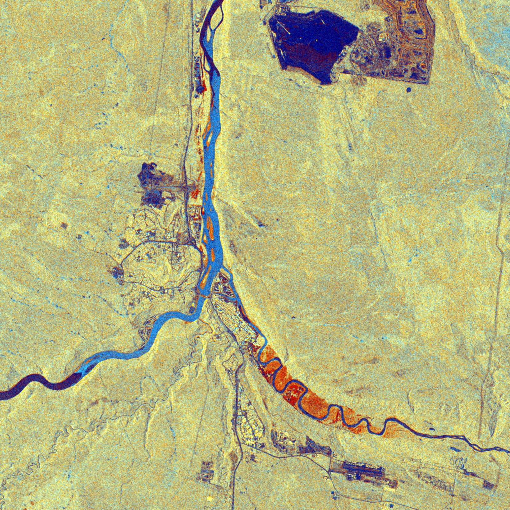
Floodwaters pour into Abbotsford, B.C., from Washington's Nooksack River, 2021
Location: Nooksack River, WA, Sumas River, B.C., near Abbotsford.
Dates: 20211116 – 20221210.
Floodwaters delineated from satellite radar using a proprietary machine learning algorithm.
Atmospheric rivers dropped 150 mm rain in southern BC over two days in November 2021. In Washington state, the Nooksack River heads west to the Pacific Ocean. It burst its banks, the flows changed course and flooded north into the headwaters of the smaller Sumas River. The cross-border river flows passed into British Columbia and flooded the Abbotsford area and Sumas Prairie, November 16 – December 10, before draining into the Fraser River.
This animation shows the Nooksack/Sumas maximum flood extent and then the progression of flooding along the course of the Sumas River. The northern end of the Sumas Prairie nearest the Fraser River holds flood waters the longest. Some of the Sumas Prairie ponds smaller areas of flood water longer than the event itself, partly due to the draining of Sumas Lake years ago.
Athabasca River Ice Jam and Flooding at Fort McMurray, 2020
Location: Confluence of Athabasca River and the Clearwater Rivers at Fort McMurray, AB.
On 24 April, 2020 the Athabasca River and the Clearwater River at Fort McMurray, AB were filled with winter ice. By the 28th, during the spring melt, an ice jam about 22 km long formed in the shallow Athabasca Channel with numerous islands. The ice jam impeded downriver flows. This raised the levels of the Athabasca and Clearwater Rivers. The town flooded from the north, and then along the River front along the Clearwater from the north-east. The flooded Clearwater River also backed up flows into Saline Creek, found at the southern limit of town, which flooded the town from the southeast.
In this image the ice jam on the flood water is shown as light blue. Open water is dark blue. The flooded areas, including islands in the Athabasca, streets in town, and the Clearwater River valley, are shown as orange. Mining is visible in the north.
About NGE
NGE delivers state of the art monitoring capabilities to detect and respond to changes on land, water, and ice faster, more accurately, and at costs lower than ever before. NGE is the global leader for providing actionable hazard information from satellite radar about freshwater ice. NGE is among the leading pack of international firms specializing in overland flooding. We are small and so work well with leadership at the municipal or city level.
Harnessing an in-house near real-time hardware and software platform since 2023, NGE’s radar pipeline can pre-process and perform automated machine learning algorithms on satellite radar data in as little as 6 hours after overpass, day or night, in all weather conditions. Pushed to devices on the internet and cellular networks, clients can be assured actionable data that meets scientific rigor.
NGE Inc. is a Canadian company founded in 2017 that leverages data from radar satellites, drones, and has prowess in field validation. As a trusted partner to the private sector, remote First Nations, NGO’s, and government including the Canadian Space Agency and Agriculture Canada, NGE delivers intelligence that detects changes due to climate variability that resonate with sectors including ice travel and arctic defense, emergency response and recovery, insurance, indigenous communities, and biodiversity and forest restoration in agriculture.

-
Satellite Imaging: FloodFinder™ utilizes all-weather satellite imaging to deliver near real-time data on the extent of floods and potential risk factors. This continuous flow of information allows for timely and accurate assessment of flood situations, providing essential data for decision-makers.
GeoPosts: A unique, geographically enabled social media tool within the FloodFinder™ platform, GeoPosts facilitates real-time communication and information sharing. This feature allows community members to report on local conditions, share observations, and receive updates from local authorities, enhancing the overall responsiveness and coordination during flood events.
-
Targeted Outreach: FloodFinder™ engages with local government leaders and community members, providing a platform to raise awareness about flood risks and the importance of preparedness. This outreach includes educational initiatives to help the public understand the implications of flood data and how to respond effectively.
Customized Alerts: The platform offers users the ability to set up customized alerts tailored to specific needs and preferences. These alerts provide timely notifications about changing flood conditions and recommended actions, enabling residents and officials to take proactive measures to protect lives and property.
-
Targeted Implementation: Initially designed for municipalities across Manitoba, FloodFinder™ is set to expand its reach across Canada. The platform is tailored to address the unique flood management challenges of each region, offering localized solutions to improve preparedness and response.
Resource for Municipalities: FloodFinder™ serves as a vital tool for local governments, helping them monitor and manage flood risks more effectively. It supports both emergency response operations and long-term planning efforts, providing comprehensive data and insights to guide decisions.
-
Near Real-Time Data Fusion: By integrating satellite data with inputs from the community, FloodFinder™ offers a holistic view of flood conditions. This data fusion approach ensures that both public and official responses are based on the most accurate and up-to-date information available.
Accessibility: The platform is cloud-based and accessible to both local authorities and the general public, making it a widely available resource for critical flood-related information. This accessibility helps ensure that all stakeholders have the information they need to make informed decisions.
-
Coordinated Response: The platform enhances communication and coordination among community members, local government, and emergency responders. This improved interaction facilitates a more organized and effective response to flooding events.
Incident Management: FloodFinder™ supports standardized communication protocols and auditing during flood events, helping to streamline the response and recovery process. This feature is essential for maintaining transparency and accountability in emergency management.
Contact us about our FloodFinder™ initiative to stay informed about flood risks and preparedness measures.
Stay updated with near real-time data, participate in community discussions, and be an active part of enhancing flood resilience in your area.